Thursday 31 March 2011

AONB produces A to Z of historic features of importance to local people

Clapper Bridge in the AONB

In 2010 the AONB created an A to Z of locally distinctive historic features in the AONB. This was based onthe results of a brief survey which was conducted via the AONB Annual Forum, and a written request to local Woman's Institutes and Parish Councils. The survey asked people in the AONB to identify their favourite local historic feature and say why it was special to them. This list is, of course, in no way comprehensive either in content or in geographical coverage. It is idiosyncratic, personal and local, but it starts to capture heritage that is important locally. Click here for full list.
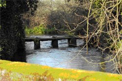


B for BRIDGES

Bridges over the Nadder and disused water meadow structures Nadder valley. It is special to me because of the evidence of works and systems which are historically important and give us a glimpse of the past.
D for
DROVEWAYS

The Droves in the Chalke Valley. They are special to me because it provides real evidence of the history of life in south Wiltshire and relationship to Salisbury.
M for MILITARY CAP BADGESAnzac Badge, cut into the chalk on Lamb Down, just outside Codford. It is special to me because It is synonymous with Codford's recent military history, and is also a reminder of our fellowship with others across the world
P for PONDS
Ashmore Village Pond. It is special to me because it is in the centre of the village
S for SUNKEN LANESSunken Lanes in the Melbury Abbas Area.It is special to me because it creates an air of mystery as gateways open up fantastic views of the chalk downland.


The A to Z forms part of the wider AONB Historic Environment Action Plans

Monday 28 March 2011

Industrial Archaeology in the Cranborne Chase and West Wiltshire Downs AONB

 Industry in the Cranborne Chase and West Wiltshire Downs AONB has tended to be small scale and local as befits a predominantly rural area, utilising local geology and materials. This paints a picture of small scale local industry serving local villages and farms and the surrounding market towns.The industrial archaeology of the AONB is an understudied component of the areas history. There are few post Medieval industrial sites recorded in the county based sites and monuments record. Nearly all former industrial activity has now ceased with the exception of limited stone quarrying in the AONB.

The industrial development of the AONB in the 20th Century has followed a slightly different course, with the expansion of small scale commercial endeavors situated away from villages and farm complexes. This includes a wide range of activities including modern telecommunications, game farms, granaries and commercial chicken farming.

Archaeological evidence relating to former industrial activity in the AONB can be grouped into three categories: -

1. The generation of power through the harnessing of water and wind, and the exploitation of that power to grind corn, to make cloth, and to pump water.
2. The exploitation of raw materials through quarrying for building material and for the creation of secondary products.
3. The manufacturing of brick, tile and lime.

Many of these processes have a long history, quarrying for example can be dated back to the Iron and Romano-British periods. However until the 19th century and the coming of the Railways these industrial activities tended to be small scale in operation and to serve primarily local needs. During the industrial revolution larger scale industrial sites were developed including brick and tile works and cloth factories, which could exploit the new markets provided by the railways. For more information visit http://www.historiclandscape.co.uk/exploring_industry.html

English Heritage is inviting the public to nominate industrial heritage

English Heritage is embarking on a project to find out how much of the country’s industrial heritage is at risk of neglect, decay or even demolition and to raise the debate about what needs saving and how. It will reveal the results of its Industrial Heritage at Risk research, including what the public think, in October this year at the launch of the annual English Heritage Heritage at Risk register.

It is inviting members of the public to visit www.english-heritage.org.uk/industrial-heritage-at-risk for more information and to post photographs and comment on favourite industrial buildings on a Flickr group run in association with the Council for British Archaeology and the Association for Industrial Archaeology.

The English Heritage Heritage at Risk register provides an insight into the condition of the country’s listed buildings, scheduled monuments, registered parks, gardens and battlefields, protected wrecks, conservation areas and listed places of worship. It gives communities – local people, local authorities and the larger community of both official and voluntary heritage groups – accurate information about the condition of local neighbourhoods. It encourages them to become actively involved in restoring what is precious to them, and ensures that public funding goes to the most needy and urgent cases.

Friday 25 March 2011

English Heritage has made the Atlas of Rural Settlement available as GIS data

Since its publication by English Heritage in 2000, Brian Roberts and Stuart Wrathmell’s ‘An Atlas of Rural Settlement in England’ has become a key point of reference for understanding the development of rural settlement in England. The maps of 19th century settlement and terrain from the Atlas are now available as data that can be used in Geographic Information Systems (GIS) software and viewed in ‘geobrowsers’ like the Google Earth* mapping service. See the English Heritage Website

Thursday 24 March 2011

Wardour Castle hosts Shakespeares Globe Theatre in June

The magic of the semi-ruined Wardour Castle is perfect for Shakespeare’s tale of disguise and mistaken identity, As You Like it. See the Salisbury Festival website for more information

Wednesday 23 March 2011

Visit the Wylye Valley Arts Trail Saturday 28th May to Sunday 5th June


Don't miss the sixth Wylye Valley Art Trail, a nine - day festival of visual arts in and around the Wylye Valley, South Wiltshire. 
 
It's a unique opportunity to see the wide range of art being carried out in this area. Visit open studios, exhibitions and galleries, meet and talk to artists and craftspeople. 

Much of the work on view is for sale and many of the artists and craftspeople involved will work to commission.

Everything you need to know is on the website http://www.wvat.co.uk/home.htm

Tuesday 22 March 2011

Storytelling Event at Ancient Technology Centre Cranborne Sat 9th April

Storytelling in the Earthouse


‘The Harper’s Trade’ Storytelling with Nick Hennessey
An energetic and enthralling performance, turning on the simple power of word and song.

Ancient Technology Centre Cranborne Sat 9th April In every song there is a story, and in the the heart of every story there is a song. Singer, songwriter, storyteller and musician Nick Hennessey explores the common ground between the spoken word and the song, the note and the phrase, drawing together Finnish epic, British ballads and his own compositions. An evening of powerful stories and rich images held on the shimmering note.


For tickets contact Pascale Barnes on 01725 517618 or p.d.barnes@dorsetcc.gov.uk

New Church Conservation Trust Leaflets reveal special places of worship in the AONB

These new leaflets will allow you to explore the churches in the care of the Churches Conservation Trust in the AONB and further afield.

See http://www.visitchurches.org.uk/publications/

Monday 21 March 2011

Conference on the Archaeology of Cross Channel Neolithic 6th to 8th May 2011


Bournemouth University is to host a major international conference on 6th May to 8th May organized by the Prehistoric Society and Bournemouth University Archaeology Group in association with the Neolithic Studies Group and the Société Préhistorique Française Archaeological work on both sides of the English Channel / la Manche in recent years has started to throw new light on the origins and development of early farming communities in the Channel coastlands (and further afield in Britain and Ireland) during the fifth and fourth millennia BC, and on the issue of cross‐Channel contact.

Further details and on‐line registration can be found at:
www.bournemouth.ac.uk/conservation/conferences/cross‐channelneolithic

New online video showing how we can respond to climate change in Cranborne Chase includes impact on heritage

Natural Landscapes - Chalk DownlandThe AONB including yours truely contributed to this Natural England project. It aimed to identify the local responses required to safeguard our natural environment and our enjoyment of it.
They looked at four specific Character Areas in England, including Dorset Downs and Cranborne Chase, that represent contrasting habitats and landscapes that are likely to be affected by climate change.

The full video has been uploaded to the video uploaded to http://www.naturalengland.org.uk/regions/south_west/ourwork/climatechangeproject.aspx

Friday 4 March 2011

Check out the photos from the Historic Environment Action Plan Project Launch

Images from the Cranborne Chase and West Wiltshire Downs Area of Outstanding Natural Beauty Historic Environment Action Plan Launch can now be views on Flicker

Use a Vision of Britain Website - to access historical maps, statistical trends and historical writings between 1801 and 2001

img description


I have found the Vision of Britain website an excellent resource in accessing historic parish level census data and understanding the history of ancient parishes boundary changes. The searchable section on historical travel writing is also extremely useful.